1. Project Overview: Supporting a Solar G99 Application
Rockall Projects was commissioned to carry out a detailed drone photogrammetry survey on a proposed solar farm site in support of a G99 application—an essential step in gaining approval for grid connection in the UK. G99 applications require accurate and up-to-date topographical data to help assess the feasibility and technical compliance of renewable energy systems connecting to the electricity grid.
The site in question was a rural parcel of land identified for mid-scale solar development. Time was of the essence, with project stakeholders aiming to submit their application within a strict planning and funding timeline. Traditional ground-based surveying methods, while accurate, would have extended the project by several days, if not weeks. That’s where Rockall Projects' drone survey capabilities offered a distinct advantage.
Using aerial photogrammetry, Rockall was able to collect comprehensive topographic data over the entire area in a fraction of the time it would take conventional teams. The survey covered contours, features, and critical elevation changes, enabling precise modelling for both planning submission and engineering design.
This survey didn’t just support planning—it became the foundation for everything that followed, including grid impact assessments, design layout, and cable routing. With drone-derived data providing confidence in both terrain and scale, Rockall’s client could proceed with clarity, speed, and precision.
2. Why Drone Photogrammetry? Accuracy Meets Efficiency
Drone photogrammetry has rapidly become the gold standard for surveying in renewable energy projects, and for good reason. When Rockall Projects took on the task of supporting a time-sensitive G99 application, precision and speed were non-negotiable. Aerial photogrammetry offered the perfect solution — merging high-resolution imagery with advanced processing to generate millimetre-accurate 3D site models.
Unlike traditional survey methods that require boots on the ground, drone photogrammetry captures vast areas quickly, with minimal disruption to the site. In the case of this solar project, the entire site was captured in under an hour — a task that could have taken multiple days using conventional techniques.
Accuracy wasn’t compromised in the name of speed. Using ground control points and automated flight paths, Rockall was able to ensure consistent data quality across the site. The resulting point cloud and orthomosaic data not only matched client expectations, but exceeded the precision requirements typically demanded for G99 documentation.
Beyond just terrain mapping, photogrammetry supports early-stage design work. Engineering teams can extract contours, assess drainage patterns, and plan cable routes with confidence, all from a shared, visual dataset. For stakeholders working across disciplines, this visibility reduces delays, avoids design clashes, and streamlines approvals.
By combining efficiency with technical rigour, drone photogrammetry didn’t just support the G99 process — it helped accelerate the entire solar project timeline.
3. Deploying the DJI Matrice 4: High-Performance Mapping
For this project, Rockall Projects deployed the DJI Matrice 4, a next-generation drone built for enterprise-level mapping and surveying. Chosen for its precision engineering, reliability in complex environments, and advanced payload integration, the Matrice 4 played a crucial role in achieving millimetre-level accuracy across the site.
Equipped with a high-resolution RGB sensor and Real-Time Kinematic (RTK) GPS, the drone delivered incredibly sharp aerial imagery and precise geolocation data. This meant every photo captured during flight could be matched to exact coordinates on the ground — a requirement for high-accuracy photogrammetry outputs.
One of the key benefits of the Matrice 4 in this application was its ability to cover large areas in a single flight, reducing operational time while maintaining consistent quality. Smart flight planning allowed the drone to automatically follow optimal grid paths, ensuring 80–90% image overlap — a crucial factor for generating detailed 3D point clouds and orthomosaics.
Rockall’s drone operators worked under full CAA-compliant procedures, ensuring safety, legal compliance, and minimal risk. The system’s built-in redundancies — from obstacle avoidance to battery backups — allowed the team to fly confidently even in semi-rural areas with varying terrain.
With the Matrice 4’s cutting-edge capabilities, Rockall was able to collect the site’s full photogrammetric dataset in under an hour, setting a new benchmark for speed and precision in solar development surveys.
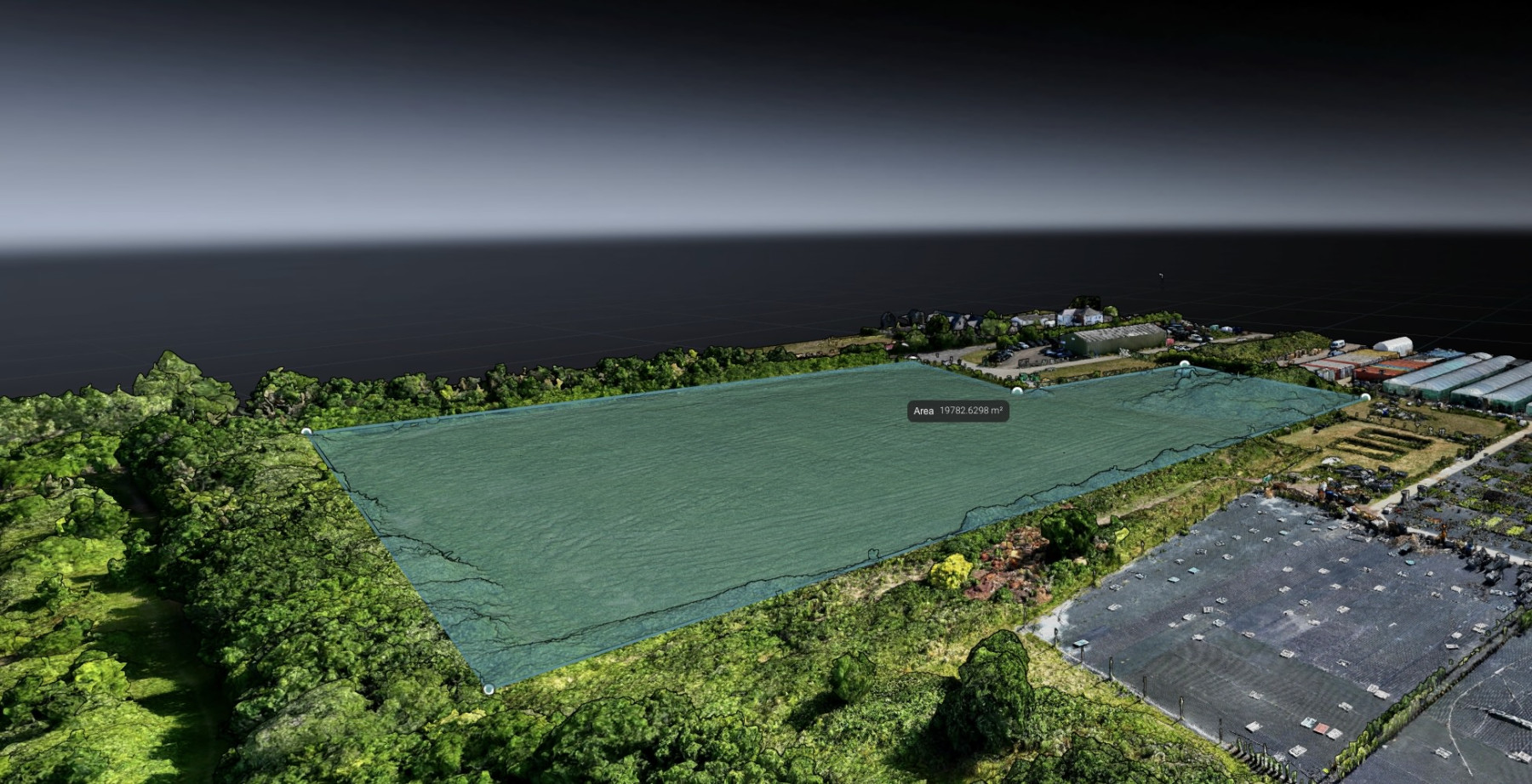
4. Deliverables via HXDR: Simple, Sharable, Secure
Once the data was captured and processed, Rockall Projects used HXDR — a cloud-based digital reality platform — to deliver the survey outputs to the client and project partners. In a process that is often bogged down by bulky files and specialist software, HXDR offered a seamless, intuitive way to access, explore, and collaborate on complex spatial data.
Through HXDR, stakeholders could log in via a secure web portal to view 3D models, point clouds, orthomosaics, and annotated topographic layers — all without needing technical GIS software or high-powered machines. With just a browser, users could zoom into high-resolution aerial imagery, measure distances, inspect terrain elevations, and even overlay engineering designs.
For teams working across disciplines — from planners to electrical engineers — this real-time access proved invaluable. The G99 application process was smoother thanks to the easy extraction of data in multiple formats, and because the deliverables were cloud-based, updates and revisions could be made without creating version control chaos.
HXDR’s secure infrastructure also helped satisfy data protection and regulatory requirements. Files were encrypted, access was permission-based, and the entire workflow could be audited for compliance — a key consideration when working on energy infrastructure projects.
By combining HXDR with drone photogrammetry, Rockall Projects didn’t just deliver a dataset — they provided a fully interactive, collaborative site model that shortened decision timelines and simplified technical workflows.
5. Benefits for Planning & Compliance in Renewable Projects
In the renewable energy sector, every project milestone is tied to regulatory compliance and planning precision. For this solar development, Rockall Projects’ drone survey played a pivotal role in helping the client stay both ahead of schedule and aligned with requirements — particularly in relation to the G99 application.
One of the key advantages of drone-based surveying is the reduction in planning uncertainty. With accurate terrain models and site boundaries defined to millimetre precision, planning consultants can prepare layouts with confidence, knowing they’re working from verifiable data. This accuracy supports zoning decisions, shading analyses, drainage planning, and environmental risk assessments — all vital components of a successful solar project.
On the compliance front, G99 applications demand detailed data on how a proposed energy system will interact with the grid. The photogrammetry outputs supported electrical design teams in planning inverter placements, cable runs, and substations — all while maintaining minimum disruption to existing landscapes or boundaries.
In addition, the digital deliverables served as a shared reference point for every consultant and contractor involved. Whether submitting documents to planning authorities or coordinating with DNOs (Distribution Network Operators), the project team could consistently refer back to the same authoritative source of truth.
Ultimately, this drone survey didn’t just check a box for site assessment. It empowered the entire development process — reducing risk, saving time, and strengthening the case for a smooth G99 approval.
Conclusion: Setting a New Standard in Solar Site Surveys
Rockall Projects’ recent drone survey for a solar development exemplifies how modern technology can accelerate renewable energy deployment — without compromising on precision or compliance. From capturing high-resolution data using the DJI Matrice 4 to delivering fully interactive models via HXDR, the team streamlined every step of the site assessment process.
With millimetre accuracy, rapid turnaround, and user-friendly data delivery, this survey not only supported a smooth G99 application but also laid the groundwork for more informed planning, design, and collaboration. As the renewable energy sector continues to grow, drone photogrammetry is proving to be a powerful enabler — and Rockall Projects is leading from the front.