3D Scanning & Digital Twin Creation

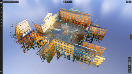
At Rockall Projects, we deliver high-accuracy 3D scanning services across the UK for buildings, structures, ships, boats, industrial assets and heritage sites. Using advanced LiDAR and photogrammetry, we create precise digital twins, point clouds, and 3D models to support design, restoration, coordination and asset management.

Whether you’re preparing for a construction project, refurbishing existing facilities, or conserving historic architecture, we help you capture real-world conditions with speed and accuracy.

What We Offer

  • 3D Laser Scanning (LiDAR) – fast, non-intrusive capture of environments with sub-centimetre accuracy
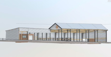
  • Scan to BIM – converting point clouds into intelligent Revit models for planning and coordination
  • Photogrammetry – ideal for detailed textures or fragile surfaces
  • Digital Twin Creation – full spatial and geometric replication of physical assets for lifecycle management

We deploy trusted equipment such as Leica RTC360, Trimble X7, and FARO Focus scanners, depending on your needs.

What We Scan

  • Commercial & Residential Buildings – As-built surveys, extension planning, fit-outs
  • Structural & Civil Assets – Bridges, tunnels, retaining walls, bespoke infrastructure
  • Marine Vessels – Scans of boats, yachts and ships for refits, insurance, or custom design
  • Historic & Listed Buildings – Non-invasive surveys ideal for conservation or architectural heritage records
  • Industrial & Plant Facilities – High-detail plantroom scans for clash detection, retrofits or system upgrades

Deliverables You Can Use

We provide data in the format that fits your workflow:

  • Point Clouds (E57, RCP, LAS)
  • Mesh Models (OBJ, STL)
  • Scan-to-BIM Revit Models
  • 2D Drawings (DWG, DXF)
  • Virtual walkthroughs, fly-through videos and online viewing platforms

All data is georeferenced and registered, ready for use in AutoCAD, Revit, Navisworks, or BIM 360.

Why Rockall Projects?

  • Construction Expertise – We’re not just surveyors – we understand the real-world needs of project teams
  • Accurate, Fast & Reliable – We meet your programme deadlines without compromising precision
  • UK-Wide Coverage – Rapid mobilisation across the South West, London, and the wider UK
  • Trusted Equipment & Methods – Using industry-leading scanners and registration tools
  • Scan + Advise – We help interpret your data, not just hand it over

Typical Use Cases

  • Pre-refurbishment as-built surveys
  • Scan-to-Revit for architectural design
  • Digital twin creation for long-term asset management
  • Ship/boat scans for design retrofit
  • Heritage records for conservation and funding applications

FAQs

How accurate are your 3D scans?
We typically achieve ±2mm accuracy using LiDAR-based scanners such as the Leica RTC360 or Trimble X7, depending on site conditions and scope.

Can I create a digital twin from your scan?
Yes – we offer full scan-to-BIM services or deliver structured point clouds that can be developed into a digital twin for use in facility management or virtual inspections.

Do you offer marine or vessel scanning?
Yes. We scan all types of vessels, both afloat and in dry dock, supporting refits, repairs, structural review or documentation.

What’s included in your deliverables?
We’ll agree your output needs in advance – typically point clouds (RCP, E57), mesh files, Revit-ready BIM models, and 2D CAD. We also provide viewing tools for visual presentation.

How quickly can you scan and deliver?
On smaller projects, we can scan in one day and deliver point clouds within 48 hours. BIM or Revit model creation typically takes 5–10 working days depending on complexity.

Reach out to see how we can assist you

For expert advice and consultancy on your project, contact us today.